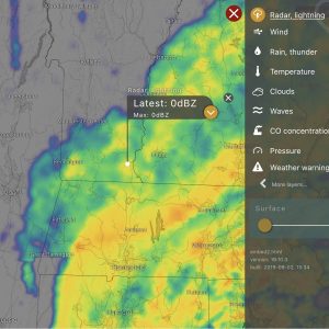
As Tropical Storm Elsa wends her way up the coast, it seems as good a time as any to point out our new weather feature — an interactive weather map! We’re very happy with the new functionality, having lost access to the National Weather Service maps about a year ago.
Before telling you more about the map and its many features, here’s how to find it: go to the iBrattleboro Weather Page and scroll down past the forecast and weather links where you’ll find it labeled Weather Map and Radar. There she blows, and isn’t she a beauty?
The new map has lots of features, but the default view is radar and lightning. If there are thunderstorms around, it’s fun to see the map flash to tell you where those storms are happening. But there’s more. Click the red arrow at the bottom of the map to “put the map in motion.” It goes back about an hour and a half in time to show you the rough trajectory of current weather.
As with most such maps, you can zoom in or out to see more detail. You can also drag the map around to look at other areas of the country and see what’s going on weather-wise. This is useful if you plan to travel or have friends and family to check in on.
If you want to try out some other views, click the icon in the top righthand corner of the map (labeled Radar, lightning for the default view). This will bring up a menu of map options including Wind, Rain and Thunder, Temperature, Clouds, Waves, CO Concentration, Pressure, and a somewhat mysterious Weather Warning option. There are other features that we haven’t figured out yet, but so far, it seems like plenty of weather info.
There is one feature that’s a tad annoying — if you click the orange arrow in the flag associated with our location, a forecast grid appears at the bottom of the map. This would be ok if you could dismiss it when you’re through looking at it, but the only way to get rid of the forecast grid is to reload the page. So it goes. It’s easy enough to just hit refresh when you want it to go away.
Hope you enjoy the new weather map. I think as the seasons evolve (and our weather along with them), you may find it a useful tool.


Fun!
The more I play with this the more I like it… the little marker for Brattleboro changes status depending on what map you are looking at. Click on the wind map and it changes to wind speed. Look at temperatures and it tells the local temp. And so on.
I like watching the real-time lightning and winds. And having the CO2 and ozone layers is a treat.
Of course, I’m a weather geek…. : )
Hey this is cool!
Way better than the static NOAA or the hysterics of the Weather Channel. Thanks!
On air talent
Since it is DIY, we have better looking forecasters, too…. (all y’all…. : ) )
Sure has come in handy the last few days with all these storms and weather changing rapidly.